
Massachusetts, October 14, 2025
News Summary
A nor’easter is currently affecting Massachusetts, causing strong winds and heavy rainfall. Rainfall amounts are expected to total between 1 and 4 inches, with potential flooding in urban areas and coastal impacts reported. Residents face travel hazards and power outages due to the severe weather conditions. Wind gusts have been recorded up to 55 mph, prompting advisories and warnings for coastal areas. Conditions are anticipated to improve by Tuesday afternoon, with temperatures remaining cool throughout the week.
Boston — A nor’easter is impacting Massachusetts on Monday, bringing strong winds and heavy rainfall.
What happened
Conditions across the state have deteriorated as the storm moves through. StormTeam 5 meteorologist Kelly Ann Cicalese states that conditions will remain challenging, with continued rainfall and wind effects lingering. The system has produced heavy rain, strong gusts and coastal impacts that have affected travel, utilities and low-lying shoreline areas.
Rain and flooding
Rainfall amounts are predicted to total between 1 and 4 inches through Tuesday:
- 1-2 inches expected in western Massachusetts.
- 2-4 inches anticipated in eastern Massachusetts, with localized amounts exceeding 4 inches possible in southeastern regions.
Plymouth County has reported as much as 4 inches of rain, with an additional inch expected. An audio report indicated that 1-3 inches had already fallen across southeastern Massachusetts by Monday morning. The Boston area received between 1 and 2 inches of rain, with reports of localized flooding in urban areas. There are concerns about ponding on roads for those traveling during the holiday, and minor inundation and splashover are expected during high tide Monday evening.
Wind and coastal impacts
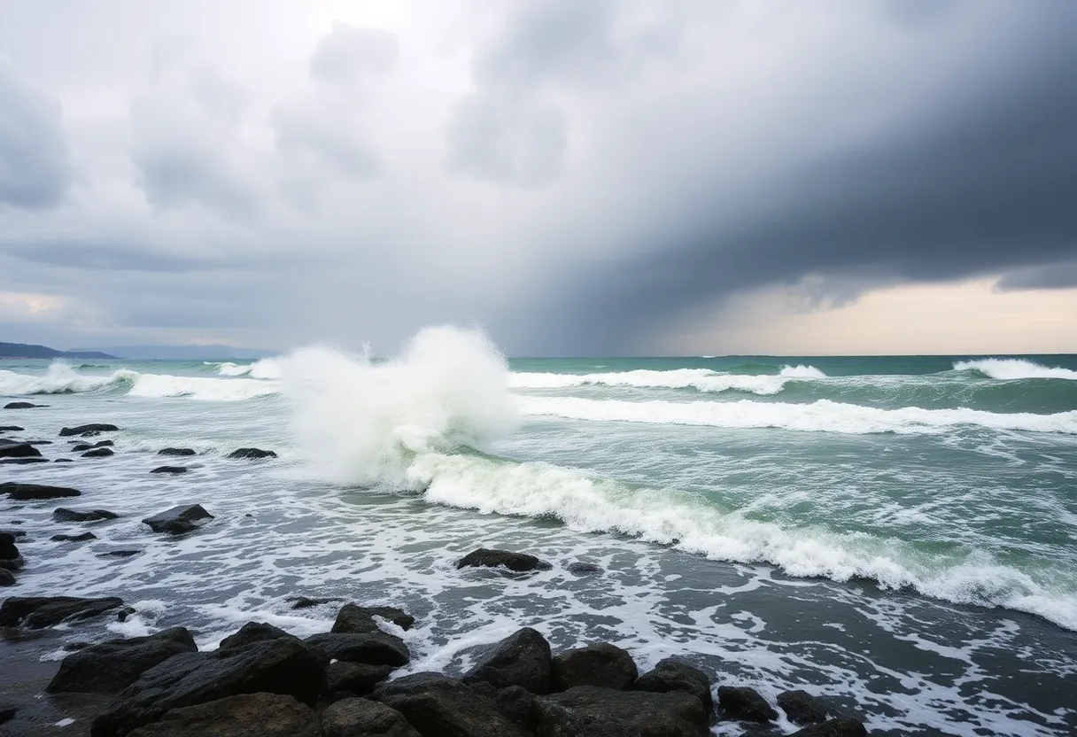
Winds have been gusting between 30 and 45 mph, with instances reaching above 50 mph off the coast. Wind gusts reached up to 55 mph in Southeastern Massachusetts, with Block Island registering 48 mph and Logan Airport at 47 mph. A wind advisory is in effect for Cape Cod and a high wind warning for the Islands through 8 p.m. on Monday.
The nor’easter is expected to produce minor coastal flooding and beach erosion, especially in low-lying areas during high tide. Coastal areas reported wave heights of 6 to 15 feet during high tide cycles. Minor inundation and splashover are expected during high tide Monday evening.
Impacts to residents and services
Possible power outages and downed trees due to high winds and heavy rain have been reported. Power outages affected nearly 4,000 customers across Massachusetts by Monday evening, with significant outages in the Boston area. Residents south of Boston should remain alert for scattered showers throughout the evening. Another round of rain is expected overnight, potentially accompanied by thunder near the coast.
Travel and safety
Road hazards include standing water and localized flooding in urban and low-lying areas. Travelers are advised to plan for slower trips and to avoid flooded roadways. Ponding on roads is a particular concern for those traveling during the holiday, and officials are monitoring vulnerable spots where runoff and high tides may combine.
Short-term outlook
Conditions will begin to improve by Tuesday afternoon, along with a return to sunshine by Wednesday. Following the storm’s passage, temperatures across the week are expected to remain cool, with highs in the 50s and low 60s.
Key facts at a glance
- Rainfall amounts are predicted to total between 1 and 4 inches through Tuesday: 1-2 inches expected in western Massachusetts; 2-4 inches anticipated in eastern Massachusetts, with localized amounts exceeding 4 inches possible in southeastern regions.
- Winds have been gusting between 30 and 45 mph, with instances reaching above 50 mph off the coast.
- A wind advisory is in effect for Cape Cod and a high wind warning for the Islands through 8 p.m. on Monday.
- Power outages affected nearly 4,000 customers across Massachusetts by Monday evening, with significant outages in the Boston area.
- Coastal areas reported wave heights of 6 to 15 feet during high tide cycles.
Advice for residents
Residents in coastal and low-lying areas should prepare for brief coastal flooding and beach erosion during high tide cycles. Secure outdoor items that could be blown about by strong gusts, and maintain a supply of essentials in case of short-term outages. Motorists should avoid driving through standing or moving floodwater.
Frequently Asked Questions
What rainfall amounts are expected?
Rainfall amounts are predicted to total between 1 and 4 inches through Tuesday:
How much rain is expected in western Massachusetts?
1-2 inches expected in western Massachusetts.
How much rain is expected in eastern Massachusetts?
2-4 inches anticipated in eastern Massachusetts, with localized amounts exceeding 4 inches possible in southeastern regions.
Has any area already received rain?
An audio report indicated that 1-3 inches had already fallen across southeastern Massachusetts by Monday morning.
What impacts have been reported so far?
Possible power outages and downed trees due to high winds and heavy rain have been reported.
How many customers lost power?
Power outages affected nearly 4,000 customers across Massachusetts by Monday evening, with significant outages in the Boston area.
What wind speeds have been observed?
Wind gusts reached up to 55 mph in Southeastern Massachusetts, with Block Island registering 48 mph and Logan Airport at 47 mph.
Are there coastal hazards?
The nor’easter is expected to produce minor coastal flooding and beach erosion, especially in low-lying areas during high tide.
What should residents south of Boston expect?
Residents south of Boston should remain alert for scattered showers throughout the evening.
When will conditions improve?
Conditions will begin to improve by Tuesday afternoon, along with a return to sunshine by Wednesday.
Quick reference table
| Topic | Details |
|---|---|
| Rainfall totals | 1-4 inches through Tuesday; 1-2 inches expected in western Massachusetts; 2-4 inches anticipated in eastern Massachusetts; localized amounts exceeding 4 inches possible in southeastern regions. |
| Recorded rain | Plymouth County has reported as much as 4 inches of rain, with an additional inch expected; An audio report indicated that 1-3 inches had already fallen across southeastern Massachusetts by Monday morning; The Boston area received between 1 and 2 inches of rain. |
| Wind | Gusts between 30-45 mph, with instances above 50 mph off the coast; wind gusts reached up to 55 mph in Southeastern Massachusetts; Block Island 48 mph; Logan Airport 47 mph. |
| Advisories/Warnings | A wind advisory is in effect for Cape Cod and a high wind warning for the Islands through 8 p.m. on Monday. |
| Power outages | Power outages affected nearly 4,000 customers across Massachusetts by Monday evening, with significant outages in the Boston area. |
| Coastal impacts | Minor coastal flooding and beach erosion expected; coastal areas reported wave heights of 6 to 15 feet during high tide cycles; minor inundation and splashover expected during high tide Monday evening. |
| Timing | Another round of rain expected overnight; conditions improve by Tuesday afternoon and sunshine returns by Wednesday. |
| Temperature outlook | Following the storm’s passage, temperatures across the week are expected to remain cool, with highs in the 50s and low 60s. |
Deeper Dive: News & Info About This Topic
HERE Resources
Fall Nor’easter Brings Heavy Rain and Strong Winds to Massachusetts
Unseasonal Nor’easter Causes Major Disruptions in Boston
Nor’easter Strikes East Coast, Causing Disruptions
Exploring October Events Across North Shore Communities
Nor’easter Set to Hit Boston This Weekend
Coastal Storm to Impact Massachusetts This Weekend
New England Faces Sharp Temperature Drop and Freeze Warnings
Delta Air Lines Expands Flight Options from Boston Logan
New South Coast Rail Service Enhances Fall River Transport
Milton Moves Towards Compliance with MBTA Communities Act
Additional Resources
- CBS News: Nor’easter impacts Boston
- Wikipedia: Nor’easter
- NBC Boston: Nor’easter Tracker
- Google Search: Nor’easter
- MassLive: Nor’easter Downpour End Timing
- Google Scholar: Nor’easter
- CBS News: Nor’easter in Scituate and Sandwich
- Encyclopedia Britannica: Nor’easter
- Boston Herald: Nor’easter Heavy Rain and Winds
- Google News: Nor’easter Massachusetts

Author: STAFF HERE BOSTON WRITER
The BOSTON STAFF WRITER represents the experienced team at HEREBoston.com, your go-to source for actionable local news and information in Boston, Suffolk County, and beyond. Specializing in "news you can use," we cover essential topics like product reviews for personal and business needs, local business directories, politics, real estate trends, neighborhood insights, and state news affecting the area—with deep expertise drawn from years of dedicated reporting and strong community input, including local press releases and business updates. We deliver top reporting on high-value events such as Boston Marathon, Head of the Charles Regatta, and Boston Harborfest. Our coverage extends to key organizations like the Greater Boston Chamber of Commerce and Associated Industries of Massachusetts, plus leading businesses in finance, biotech, and insurance that power the local economy such as Fidelity Investments, Biogen, and Liberty Mutual Insurance. As part of the broader HERE network, we provide comprehensive, credible insights into Massachusetts's dynamic landscape.