
Rhode Island, September 1, 2025
News Summary
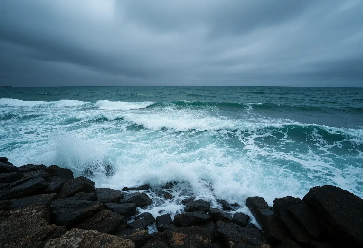
Hurricane Erin is set to pass southeast of Nantucket, leading to dangerous surf and strong rip currents along Rhode Island’s coastline. Authorities have issued a High Surf Advisory until Saturday morning, warning of large breaking waves and severe thunderstorms. With expected surf zone waves reaching 6 to 10 feet and strong winds up to 30 knots, beachgoers and mariners are advised to exercise extreme caution.
Providence — Hurricane Erin is expected to pass southeast of Nantucket on Friday and generate dangerous surf and strong rip currents along the Rhode Island shoreline. Authorities have issued a High Surf Advisory through 8 a.m. Saturday and a Gale Warning for coastal waters from Thursday morning through Friday afternoon. Large breaking waves, strong onshore winds, and the potential for severe thunderstorms pose hazards to beachgoers, boaters, and coastal infrastructure.
Immediate conditions and timing
The National Weather Service predicts surf zone waves will peak at 6 to 10 feet by Friday, producing strong rip currents and hazardous shorebreak. Offshore seas are forecast to rise to 8 to 13 feet in the warned areas. The gale warning covers Rhode Island and Block Island sounds, as well as Vineyard Sound and Buzzards Bay off Massachusetts.
Northeast winds of 20 to 30 knots with gusts up to 40 knots are expected during the warning period. These conditions can produce hazardous seas, reduced visibility, and rapidly changing marine conditions. A separate severe thunderstorm warning has been issued for parts of Rhode Island on Friday afternoon, with the potential for winds near 60 mph capable of damaging trees and power lines.
Primary risks
Surf and rip currents
The combination of large breaking waves and strong nearshore currents will increase the likelihood of life-threatening rip currents. Even onlookers standing on normally safe viewing areas or rocks can be swept into the water by a large wave or sudden surge.
Marine hazards
Strong winds and high seas create dangerous conditions for small craft and larger vessels alike. Hazardous seas can capsize or damage boats and make navigation and rescue operations more difficult. Reduced visibility from spray and rough water is likely where winds are strongest.
Thunderstorm impacts
Severe thunderstorms accompanying the system may bring damaging straight-line winds near 60 mph, which can topple trees, snap large branches, and cause localized power outages. These storms can also produce sudden, strong gusts over exposed coastal areas.
Public safety guidance
Mariners are advised to alter plans to avoid hazardous conditions. Options include delaying departures, staying in port, or seeking safe harbor until conditions improve. Vessel operators should secure loose gear and monitor forecasts closely.
Beachgoers and coastal residents should exercise caution: stay near lifeguarded areas when open, heed public safety announcements, and check beach warning flags before entering the water. The Rhode Island Department of Environmental Management (DEM) will closely monitor conditions and may implement swimming restrictions if necessary. State officials are urging residents and visitors to avoid unnecessary exposure to the shoreline during peak wave and wind periods.
What to watch and prepare for
- High Surf Advisory remains in effect through 8 a.m. Saturday; expect strong rip currents and dangerous shorebreak.
- Gale Warning in effect from Thursday morning through Friday afternoon for specified coastal waters.
- Peak surf zone waves of 6 to 10 feet expected Friday; offshore seas 8 to 13 feet.
- Northeast winds of 20–30 knots with gusts up to 40 knots; severe thunderstorm threat with winds up to 60 mph possible Friday afternoon in parts of Rhode Island.
- Mariners should consider staying in port or seeking safe harbor; beachgoers should stay near lifeguards and follow flag warnings.
Background and context
High surf advisories and gale warnings are standard coastal weather products used to highlight elevated risk from waves, currents, and winds that can threaten public safety and marine operations. Rip currents form when large waves push water toward the shore and that water returns to deeper water through narrow channels. Even strong swimmers can be overwhelmed by rip currents and shorebreak from 6–10 foot waves.
Rhode Island’s shoreline, with multiple public beaches, rocky points, and tidal sounds, is particularly vulnerable to rapidly changing conditions when a hurricane or tropical system moves nearby. Local agencies coordinate monitoring, beach flagging, and emergency response planning to reduce injuries and property damage during periods of high surf and wind.
How authorities are responding
The Department of Environmental Management will monitor beaches and may impose swimming restrictions if conditions become too hazardous for lifeguard operations. Emergency management and maritime authorities recommend that the public avoid unnecessary travel along exposed coasts during strong onshore wind and high-wave events and prepare for possible localized outages if thunderstorms produce damaging winds.
Frequently Asked Questions
What areas of Rhode Island are expected to be affected?
Coastal areas along Rhode Island’s shoreline, including beaches and points near Block Island Sound, Rhode Island Sound, Vineyard Sound, and Buzzards Bay, are expected to experience elevated waves, rip currents, and strong winds. Inland areas may see impacts from severe thunderstorms in parts of the state on Friday afternoon.
How high will the waves be?
Surf zone waves are forecast to peak at about 6 to 10 feet by Friday, with offshore seas reaching 8 to 13 feet in warned waters.
What does a High Surf Advisory mean for beachgoers?
A High Surf Advisory indicates dangerous surf and strong rip currents that can make swimming and being near the water hazardous. Beachgoers should stay close to lifeguarded sections, obey flag systems, and avoid walking on jetties, rocks, or other exposed areas.
What should mariners do?
Mariners should consider staying in port, delaying trips, or seeking safe harbor while the Gale Warning is in effect. Secure vessels, monitor forecasts, and avoid exposed waters until conditions improve.
Will there be swimming restrictions?
State environmental and public safety officials are monitoring conditions and may impose swimming restrictions or close beaches if lifeguards cannot safely operate. Visitors should follow posted warnings and official announcements.
Quick Reference: Warnings, Timing and Recommended Actions
| Item | Details | Recommended Action |
|---|---|---|
| High Surf Advisory | In effect through 8 a.m. Saturday. Surf 6–10 ft near shore. | Avoid swimming except near lifeguards; expect strong rip currents. |
| Gale Warning | In effect Thu morning through Fri afternoon for coastal sounds. Winds 20–30 kt, gusts to 40 kt. Seas 8–13 ft. | Mariners should stay in port or seek safe harbor; secure vessels. |
| Severe Thunderstorm Threat | Friday afternoon in parts of Rhode Island. Winds up to 60 mph possible. | Avoid downed trees and power lines; shelter indoors if severe storms approach. |
| Beach Safety | Strong shorebreak and hazardous rip currents expected. | Heed beach flag systems, stay near lifeguards, avoid rocks and jetties. |
| Monitoring | State DEM and local authorities monitoring conditions; may impose restrictions. | Check official local announcements and follow all closures and advisories. |
Deeper Dive: News & Info About This Topic
HERE Resources
Massachusetts Closes 58 Beaches Due to Bacterial Concerns
Search Continues for Missing Man After Boat Capsizes Off Salisbury Beach
Boat Capsizes Near Salisbury Beach, One Missing
Jeffrey Charnel Honored in Boston’s ’40 Under 40′ Awards
Hurricane Erin Causes Beach Closures and High Rip Current Warnings in Massachusetts
One Rescued, One Missing After Boat Capsizes Off Salisbury Beach
Dangerous Surf and Strong Winds Impact New England Coast
Fall Adventures for Families on Cape Cod
Hurricane Erin Expected to Impact New England with Hazardous Conditions
Lyric Stage Boston Opens Season with Our Town
Additional Resources
- Turn to 10 Weather
- The Weather Channel: Providence RI 10-Day Forecast
- Patch: Severe Thunderstorm Warning in RI
- Wikipedia: Hurricane Erin
- Google Search: Hurricane Erin

Author: STAFF HERE BOSTON WRITER
The BOSTON STAFF WRITER represents the experienced team at HEREBoston.com, your go-to source for actionable local news and information in Boston, Suffolk County, and beyond. Specializing in "news you can use," we cover essential topics like product reviews for personal and business needs, local business directories, politics, real estate trends, neighborhood insights, and state news affecting the area—with deep expertise drawn from years of dedicated reporting and strong community input, including local press releases and business updates. We deliver top reporting on high-value events such as Boston Marathon, Head of the Charles Regatta, and Boston Harborfest. Our coverage extends to key organizations like the Greater Boston Chamber of Commerce and Associated Industries of Massachusetts, plus leading businesses in finance, biotech, and insurance that power the local economy such as Fidelity Investments, Biogen, and Liberty Mutual Insurance. As part of the broader HERE network, we provide comprehensive, credible insights into Massachusetts's dynamic landscape.