
Worcester, September 7, 2025
News Summary
Severe storms swept through western and central Massachusetts, resulting in a confirmed tornado near Holden, close to Worcester. Tornado warnings were issued across nearby counties, prompting alerts for communities like Marlborough and Shrewsbury. The storms caused downed trees, power outages, and localized flooding, though no extensive structural damage was reported. As the storm passed, authorities advised residents to remain cautious due to continuing weather conditions. Cooler, drier weather is expected in the coming days.
Worcester
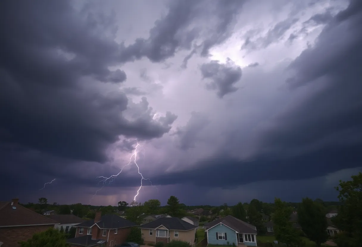
Severe storms swept across western and central Massachusetts on Saturday, with a confirmed tornado located over Holden near Worcester and multiple tornado warnings issued across Middlesex and Worcester counties. The storms moved out of the region by Saturday evening but left scattered damage, downed trees and power outages in numerous towns. No reports of extensive structural damage were noted during the storm’s passage.
What happened and where
Authorities confirmed a tornado touchdown over Holden, a community just outside Worcester. Tornado warnings covered downtown Worcester and areas to the north and northeast, remaining in effect until 4:45 PM. A broad list of communities were in the tornado’s potential path, including Worcester, Marlborough, Shrewsbury, Hudson, Westborough, Holden, Northborough, Clinton, Lancaster, Sterling, Southborough, Stow, Harvard, Framingham, Acton, Sudbury, Maynard, and Boxborough.
Alongside tornado activity, severe thunderstorm warnings were in place across parts of New England, including the Boston area, western Massachusetts, New Hampshire, Connecticut, and southern Maine. The storms brought heavy rain, frequent lightning, hail in places, and damaging wind gusts that organized into a line across the region in the afternoon.
Timing and meteorological setup
A cold front approaching the Boston area moved into an atmosphere that was hot and very humid, with temperatures in the 80s ahead of the storms. Forecasts had indicated that storms would begin developing across western Massachusetts between noon and 2 PM, then reach the Boston area by late afternoon. A severe weather watch remained in effect until 8 PM, with severe storms possible from roughly 1 PM to 10 PM.
Initial forecasts noted a low but present tornado risk in parts of western Massachusetts and northern Connecticut. The greater threats during the peak afternoon and early evening hours were heavy downpours, damaging straight-line winds, hail, and frequent lightning. By the evening the storms weakened, though clouds and scattered rain continued into Sunday.
Impact and immediate effects
Across the state, communities reported tree damage and localized power outages resulting from high winds and falling limbs. Flooding was reported in some areas due to intense downpours, and hail was observed in spots where stronger cells passed. Damage reports were generally limited, and no widespread structural devastation was documented as the line of storms moved through.
Emergency and utility crews responded to downed trees and outage reports. Some towns experienced brief interruptions to travel and local services where roads were blocked by debris.
Short-term forecast and recovery
Saturday night saw the storms diminish in intensity, though lingering clouds and rain persisted into Sunday. Southern New England should expect cool skies and steady morning rain on Sunday, especially across southeastern Massachusetts. High temperatures on Sunday were forecast to cool to the mid-60s.
Looking further ahead, a cooler week is expected as high pressure returns and brings drier air starting Monday. Next week’s temperatures are forecast to range from the upper 40s to the low 70s. A chance of showers may appear midweek, particularly on Wednesday, but otherwise conditions are expected to remain mainly dry.
Safety reminders
- Take care when traveling: watch for downed trees, flooded roads and scattered outages.
- Report power outages to your local utility and follow instructions from local emergency services.
- Avoid driving through flooded areas and give crews room to work when clearing debris.
Background
Severe thunderstorms and isolated tornadoes are not uncommon in New England during warmer months when humid air combines with advancing cold fronts. In this event, afternoon heating and an approaching cold front helped fuel a line of storms from western into central Massachusetts. While tornado risk was assessed as low for much of the region, the confirmed touchdown near Holden underscores the localized potential for rotating storms even when widespread tornado conditions are limited.
Next steps for residents
Residents in affected communities should account for possible continuing power restoration timelines and cleanup operations in the days following the storms. Monitor local official channels for updates on road closures, utility restorations and any ongoing advisories. Prepare for cooler, drier weather early next week but stay alert for a possible round of showers midweek.
Frequently Asked Questions
Was a tornado confirmed?
A tornado was confirmed over Holden near Worcester during Saturday’s storms. Tornado warnings had been issued for Middlesex and Worcester counties, including parts of downtown Worcester and areas to the north and northeast.
Which towns were affected?
Towns listed in the potential path included Worcester, Marlborough, Shrewsbury, Hudson, Westborough, Holden, Northborough, Clinton, Lancaster, Sterling, Southborough, Stow, Harvard, Framingham, Acton, Sudbury, Maynard, and Boxborough. Additional areas across western and central Massachusetts saw severe thunderstorm warnings.
What kinds of damage were reported?
Reports included tree damage, localized power outages, isolated flooding from heavy downpours, and hail in some areas. Officials indicated there was not extensive structural damage reported statewide.
How long will the storms affect the area?
The main line of storms moved through Saturday afternoon and evening and had largely exited the region by Saturday night. Clouds and rain lingered into Sunday, with cooler, drier weather expected to return by Monday.
What should residents do now?
Residents should report outages to their local utilities, avoid traveling through flooded or debris-blocked roads, and follow local emergency guidance for cleanup and safety. Preparing for cooler weather and monitoring forecasts for a chance of midweek showers is recommended.
| Topic | Information | Recommended Action |
|---|---|---|
| Confirmed tornado | Touchdown reported over Holden near Worcester. | Check local advisories and assess property for storm damage. |
| Warnings | Tornado warnings in Middlesex and Worcester counties until 4:45 PM; severe weather watch through 8 PM. | Stay informed; avoid travel while warnings are active. |
| Immediate hazards | Downed trees, power outages, localized flooding, hail, frequent lightning. | Report outages, avoid floodwater, stay indoors during lightning. |
| Short-term forecast | Storms diminished Saturday night; rain and clouds into Sunday. Highs in mid-60s on Sunday. | Plan for cooler, wetter Sunday morning; expect clearing early next week. |
| Next week | Cooler and mostly dry Monday onward; temperatures upper 40s to low 70s; possible showers Wednesday. | Monitor forecasts midweek for any change; routine outdoor plans should be OK early in the week. |
| Emergency contact | Local emergencies: 911 | Use 911 for immediate life-threatening situations; contact local utility for power outage reporting. |
Deeper Dive: News & Info About This Topic
HERE Resources
Boston Weather Shifts to Cooler Temperatures Amid Hurricane Erin
Boston Sets Record High Temperatures Amid Heat Wave
Heat Wave Hits New England with Record Temperatures
Boston Faces Heat Wave with High Humidity and Storm Risks
Boston’s Public Garden Hosts Live Paintings for Charity
Boston Faces Record Heat and Drought This June
Massachusetts Faces Record-Breaking Power Outages Amid Heat Wave
Snowstorm to Impact Massachusetts with School Closures
Severe Thunderstorm Warnings Issued for New England
Boston Weather Forecast Promises Warm June Ahead
Additional Resources
- NBC Boston: Strong Storms Moving into New England
- Wikipedia: Tornado
- Boston 25 News: Tornado Warning Issued
- Google Search: tornado massachusetts
- NBC Boston: Tornado Storms Damage Massachusetts
- Google Scholar: weather severe storms
- Boston Herald: Tornado Warning for Parts of Massachusetts
- Encyclopedia Britannica: Weather
- WHDH: Weekend Worries
- Google News: storm massachusetts

Author: STAFF HERE BOSTON WRITER
The BOSTON STAFF WRITER represents the experienced team at HEREBoston.com, your go-to source for actionable local news and information in Boston, Suffolk County, and beyond. Specializing in "news you can use," we cover essential topics like product reviews for personal and business needs, local business directories, politics, real estate trends, neighborhood insights, and state news affecting the area—with deep expertise drawn from years of dedicated reporting and strong community input, including local press releases and business updates. We deliver top reporting on high-value events such as Boston Marathon, Head of the Charles Regatta, and Boston Harborfest. Our coverage extends to key organizations like the Greater Boston Chamber of Commerce and Associated Industries of Massachusetts, plus leading businesses in finance, biotech, and insurance that power the local economy such as Fidelity Investments, Biogen, and Liberty Mutual Insurance. As part of the broader HERE network, we provide comprehensive, credible insights into Massachusetts's dynamic landscape.